Inhabited west coast Scottish Islands - Kerrera
The island of Kerrera lies just off the coast, very close to Oban. The northern end of the island, in fact, nearly blocks the entrance to Oban Bay (or the ‘little bay’ as I understand the Gaelic name to mean) and the CalMac ferries, after leaving Oban, have to head north west round the northern tip to gain access to the Firth of Lorn and the islands beyond. The island is about four miles long and about one and a quarter miles wide at the widest point. It is separated from the mainland by the Sound of Kerrera which is only about a quarter of a mile wide. The highest point, at about 620 feet, is Carn Breugach. Most maps show the Colonsay ferry heading down the Sound of Kerrera but I have only seen one of the big ferries taking this route once. Maybe, on this occasion, it was a very high tide and this route would be shorter than sailing round the north tip of the island - but only possible at a very high tide?
There are two ferry crossings to Kerrera; one just north of Gallanachbeg (known as the Gallanach Ferry) and one directly from Oban’s North Pier to the marina at Ardantrive Bay. Both are passenger ferries, although the ferry at Gallanach is able to take vehicles. It’s my understanding that the Gallanach Ferry does not take tourist cars but only work vehicles on official business (like road repairs). The ferry from Ardantrive seems to be run by the marina, or maybe the restaurant which is part of the marina (I think). Regardless of that, this ferry seems quite happy to take anyone seeking to use it. I used the Gallanach ferry to cross to Kerrera and I then walked clockwise round the island until I reached Ardantrive where I caught the ferry back over to Oban (and then paid for a taxi to get me back to my van which was parked at Gallanach ferry jetty). I have read that there is a path down the north east side of the island from Ardantrive to the Gallanach ferry but it is not marked on my map and it’s reported to be indistinct and boggy - so I decided not to try looking for it as I was already exhausted.
The island is in two parts with the northern end separated from the southern end with only a track suitable for a quad bike (or similar) linking them. I have recently read that this track is going to be upgraded to enable a better linkage between north and south.
If using the Gallanach ferry you arrive at a jetty with a few houses and other buildings. This hamlet does not appear to be named, although a further cluster of houses, just above the jetty, would appear to be called Balliemore. Maybe the houses at the jetty are part of Balliemore or maybe Balliebeg? I’ll just refer to it as the Kerrera jetty. From this jetty there are two directions to take (if sticking to a road and not just heading off overland). The first heads west up the hill, past Balliemore and over the pass at the top (a ‘bealach’, I suppose). From there the road also splits in two. One branch heads westish to Slaterich and on to Slatrach Bay (a similar name but spelled differently, as above, on my map - which is probably down to both the English and Gaelic spellings being provided). Shortly after starting out on this road the track to the north end of the island branches off. The other branch heads south westish, down a long and steep road, to a single croft (it would appear) at Barnabuck. The other option from the jetty is to turn left and head down the east coast of the island, passing a croft or farm called Ardchoirc, then on to Upper Gylen, then west over to Lower Gylen (missing out a dead end road to Gylen Park). From just before Lower Gylen there is a walking track which leads south to Gylen Castle. Gylen Castle is well worth a visit. Although a ruin, it is well preserved and, it seems, safe to go into. There is also an information board outside explaining the history of the castle. From Lower Gylen (which hosts a bunk house and a cafe) the road continues south westish to Ardmore - a single cottage and maybe also a croft. When I was there the folk who lived in this house also made perfumes and soaps etc. What was nice to see was that their goods were laid out on an unattended table. I can’t remember if there was an honesty box or if a purchaser was supposed to knock on the door to pay - but it was nice to see the expected honesty (and I hope they don’t suffer from dishonest visitors). The proper road ends at this point and a track heads north and up the west coast until it reaches Barnabuck where it rejoins the road over the hill from the jetty. Note that when I say ‘proper’ road I am being loose with my description. I am not sure if the few roads on Kerrera are mettaled or just hard packed earth - but a car could be used on them if driven carefully. It also needs to be mentioned that the road from Barnabuck up to the top of the hill (and bealach) is long, twisting and steep - so a rest at the bottom first is probably a good idea.
From the mainland coast near Oban, Kerrera looks quite lush - but this is really not the case as it is just as rugged and wild as most of the other Inner Hebrides. I think it looks lush because of the cultivated fields around Ardchoirc farm/croft and the abundance of native trees and ferns on the eastern slopes of the island’s hills. On reaching the south coast at Lower Gylen, then the west coast north of Ardmore, the island’s rugged landscape becomes more obvious (but no less wonderful). On heading south from the Jetty, I thought I’d stepped back in time to my childhood in the fifties. The best word to describe this was tranquil with only bird song to be heard, until what, I presume, was the post person rattling past on a quad bike with a couple of dogs chasing after her. I presume this was the post person because it was not long afterwards she rattled past me again, heading north this time, and she passed me a while later, heading south, on the track between Slaterich and Ardantrive.
My map also indicates a sandy beach at Slatrach Bay - but I did not go down to it as my walk was already going to be more than long enough, so I cannot say if this is a nice sandy beach or one of the muddy ones more common in the area. There were several other stoney beaches where going for a swim would be possible (as I witnessed). There are also free roaming black goats on the island. I came across a small family of them on the track to Gylen Castle. For those concerned about this I would say that they appeared docile and inquisitive and only looked at me when I stopped to photograph them. Very close to the most northern tip of the island sits the Hutcheson Monument - a large granite obelisk built in 1883 to commemorate David Hutcheson, an entrepreneur who started the sailing services to the islands. This company later became Caledonian MacBrayne before becoming CalMac. Being totally exhausted by the time I reached the marina (it was a long walk for an old man who stills smokes) I did not undertake the short walk to it for a closer look (resorting, instead, to a maximum zoom photograph).
Kerrera is a wonderful little island well worth a visit. Keep in mind, however, that there is not much in the way of tourist services apart from the cafe at Lower Gylen and the bar/restaurant (no draft beer - just cans) at the marina.

The photo above is from the Gallanach ferry looking at the jetty on Kerrera near Balliemore.

The photo above is looking towards the croft/farm at Ardchoirc. This was clearly taken from the mainland and before the first photo - but Ardchoirc is the first building after the jetty on the route I took and a clear shot of it from that road is not possible.

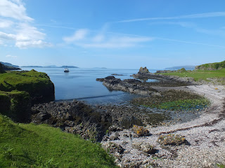
The above shot is of a terrace of cottages at the Little Horse Shoe - which is just south of Ardchoirc.

This photo is from the road above Lower Gylen towards Lower Gylen with Mull beyond.

The above photo is of Gylen Castle.
The above shot is looking east along the south coast, taken from close to Gylen Castle.

The above phot is of a small family of black goats enjoying a rest near Gylen Castle.

The photo above is of the house/croft at Ardmore, where the road down the east and south coasts of Kerrera ends.

The shot above is of the croft house at Barnabuck on the west coast of the island. This croft is still in operation if the number of sheep and cattle near by is anything to go by.

The above photo is of Slaterich with Slatrach Bay beyond. Given the direction I was looking in, I think the hills in the distance are of Morven rather than Mull (but I'd have to check with a map to be sure).

The shot above was taken near Ardantrive - possibly of Ardantrive farm.

The above shot is of the marina at Ardantrive looking towards Oban.

The above photo is of the Hutcheson Monument very close to the northern tip of Kerrera.
Comments
Post a Comment