Inhabited west coast Scottish islands - Lismore and Eriska
Lismore is a long, narrow island - but in describing it so I am more describing it’s shape rather than it’s size as it’s only about 10 miles long and 1 mile wide at it’s widest. It is fairly low lying with the highest point, Barr Mor, being only about 420 feet. It lies at the mouth of Loch Linnie, with the southern tip reaching into where Loch Linnie joins with the Firth of Lorn - with the Sound of Mull to the west and the mouth of Loch Etive to the east.
The Gaelic name is Liosmor, which means the big, or great, garden - so one has to assume that the Gaelic for garden is ‘lios’ (pronounced lis in English). It is, indeed, a very green, pleasant and peaceful place despite a car ferry service from Oban. It is a fertile island due, I understand, to the limestone in the soil (although the term ‘fertile’ might just be in respect to the surrounding lands of Morven, Appin and Mull - not to mention the majority of Scotland’s west coast). This fertility, I presume, is where it’s name derives from. There is only one shop on the island (near Ballivolan, which is slightly north of the centre of the island) and this, I presume, makes this car ferry link to Oban vital to life on the island as, given the size of the shop, I would not expect it to stock much more than basic items. There is a church just south of Clachan Baileouchdarach which hosts (outside) a display of 13th century grave markers. This church appears, for historical reasons, to be called Saint Moluag’s Cathedral. Just a bit south of this church there is also a museum and a cafe. There are also various ancient ruins (brochs, duns, cairns and castles) to visit.
As mentioned above, Lismore is pretty low lying - but try telling that to someone who decides to cycle round it, as I did. Given how low lying it looks from the mainland, I decided to take my bike over via the Port Appin passenger ferry, rather than my van (this to save on the cost of taking my van over). I soon discovered that Lismore was far from flat, despite being low lying. This resulted in me being able to cover only about half the island, mainly the northern and eastern side (down to Achnacroish, where the ferry from Oban arrives) with a short trip over to Port Ramsay on the west. I have, therefore, ticked Lismore off my bucket list - but I need to return and complete my visit to the parts not reached on my first visit.
The reason for this slow progress is due to the fact that the main road on Lismore mainly runs down the centre of the island, with several roads off to east and west to various houses, crofts and farms, and because of this it follows the rise and fall of the hills. These hills may not be high but they do provide regular inclines for a cyclist to struggle up. The up side of this is that there are fine panoramic views across the island from the top of each rise - and I did stop several times to enjoy the views.
My original plan was to head south, from Point (where the Port Appin ferry arrives at Lismore’s northern tip) via the main road and take side visits to the east to Tirefour Broch, near Balure, and then to Achnacroich before going on to where the main road ends, a bit south of Kilchern. From there the road turns into a track, which I hoped was good enough to cycle down, until this ended at Dalnarrow. This track passes a couple of other brochs and duns which I’d hoped to visit. The plan was then to return north but take the side road, to the west, to Achinduin. Off this road lie a further couple of ruins, namely Dun Cuilein and Achadun Castle, both of which I also hoped to visit. On coming back up this road I had intended to take a track on the west side which passes Grogan Dubh before it rejoins the main road near Balliveolan. A bit north of that there is another short side track, just south of the church already mentioned, with what looks like more ancient ruins to visit - Castle Coeffin in particular, as the Internet pictures of it look most impressive. From there the plan was to visit Port Ramsay on the north west coast then back to the jetty at Point to catch a ferry back to Port Appin. However, slightly south of the road to Achnacroich, I decided that my original plan was too optimistic. I had pushed my bike up the steep hill out of Achnacroich and continued a short distance south down the main road when I came to another summit with panoramic views. I could see the road ahead going down a long incline towards the southern tip of the island. Going down would be easy - but coming back up again would be slow. I concluded that there was no way that I was going to be able to get round everything I wanted to get round and get back for the last ferry back to Port Appin. I therefore decided, instead, to head back towards Point and pay a visit to Port Ramsay on the way - leaving everything else to another visit. For that reason I will pretend that Port Ramsay was my first stop after heading south down the main road.
Most of Lismore’s population seem to live in separate cottages, crofts and farms but there are two townships. Achnacroich is the largest but there is also Port Ramsay. I have to say that I found Port Ramsay rather bleak. It seems to comprise of two or three terraces of cottages along with a scattering of separate houses. There was a run down feel to the place and there was nothing that made me think I’d want to return for another visit. There appeared to be no facilities - for either tourist or local.
A bit further south on the main road, after a cluster of houses called Achuaran, there is a side road to the east towards Balure. This road also took me down to Tirefour Castle Broch. This is not the best broch I’ve seen on the west coast - but it is one of the best and was well worth the visit.
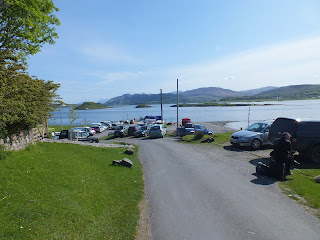
On returning to the main road, I continued south until I reached the pretty steep side road to Achnacroich (after first stopping for a look at the grave markers at the church). Achnacroich looked far more appealing than Port Ramsay did but apart from the pier for the Oban ferry there was not much to it apart from houses and, going by the childish screams and shouts, the island’s primary school. No sign of any other facilities or places of interest to visit. As mentioned above, I pushed my bike back up the steep hill to the main road and shortly thereafter decided to return north and leave visiting the rest of the island to another day. On the way back north I stopped off at the cafe for a light meal and a coffee. The place was clean and tidy and the food was more than acceptable. If, however, this cafe is the only eating place for tourists then getting a table on a busy summer day might not be easy - and it would appear to close late afternoon and not, therefore, provide evening meals.
In summary: Lismore is a lovely little island and well worth a visit. There are several birds (buzzards and razor bills, for example) and other wild life, like otters, to try and spot and there are interesting ruins to visit and many walks and cycle rides that could be undertaken - although more than a week might be less desired unless you just want to laze about for several days. Seeing everything in a single day, even with a car, might be a bit of a push. It’s biggest drawback is the lack of tourist facilities. There is no petrol station, no pub, no hotel and no restaurants with only the cafe providing food during the day (although I did read there was a fish and chip van which trades near Achnacroish pier, probably only in the evenings). If renting a self-catering cottage then bringing plenty of supplies (along with a full tank of fuel for your car) would be a good idea - although heading back over to Oban to stock up would always be an option as Oban’s shops and supermarkets are not far from the ferry terminus. I saw no family friendly sandy beaches and an examination of my maps suggests there are none - although exploring rocky ones might keep some engaged for several hours. On the plus side, there is bike hire, a taxi service and guided vehicle tours available.
And that completes my first, but incomplete, visit to Lismore. I look forward to a second visit when I hope to get to the parts I wasn’t able to on my first visit.
I am now going to include the island of Eriska in this post - simply because it is so small and uninteresting (as far as I could tell) that I didn’t want to waste a separate post on it. Eriska is a tiny tidal island which lies across the mouth of Loch Creran. It is reached via a short bridge from Balure, which is just to the west of South Shian. It is only about 360 acres in size. It consists of a rocky outcrop (about 155 feet high) on the eastern side which is mainly covered by bushes, shrubs and trees. On the south eastern tip there is a partially submerged cranog. This is about the only thing of interest on the island. The western side is flat open field - but with nothing, as far as I could see, to encourage exploration. About the only thing on Eriska, apart from the cranog, is the hotel - which I understand is quite exclusive. There is a small private golf course (6 holes) to the north of the hotel and a small, steeply sloped beach on the northern edge, with a jetty. This beach has some sand but it’s mainly stones and pebbles. There is nothing about Eriska which makes me want to make a return visit - unless going to some function at the hotel (which is most unlikely) or deciding to have a look at the cranog. Pay a visit to complete a bucket list but otherwise ignore. Note that I spoke to some hotel workers who did inform me that the hotel was occupied throughout the year (owner or manager, I presume) so including it in my bucket list was a requirement.
That completes the first leg of my inhabited Scottish west coast islands - what could be called the Southern, Inner, Coastal Hebrides. When I resume I will return south and west to Islay and Jura and then out to Colonsay.


.jpg)
Comments
Post a Comment