Inhabited west coast Scottish islands - Tiree
Tiree is a smallish island to the west of Mull - almost stuck out in the middle of the Sea Of The Hebrides along with Coll. It is in fact the westernmost island of the Inner Hebrides - and it is, for example, further west than Stornoway in the Outer Hebrides (this mainly due, however, to the arc that the Outer Hebrides lies along). It is reached either by the CalMac car ferry from Oban or by plane from Oban airport (but also from Coll and Glasgow). As said, it is smallish - but not tiny. It is larger than, for example, the island of Danna - but much smaller than Islay, Jura, Mull, Skye and the major islands of the Outer Hebrides. It is shaped a bit like an arrow head (with a broken tip) pointing north east. That makes it a bit difficult to define it’s coast lines as there is only one full coast, the west coast, which aligns reasonably well with the cardinal compass points (Note that I am talking here about the general, or average, direction
that any particular coast is facing, not just any small section which might
face pretty much north, south, east or west. It's the general direction
that each coast faces that allows me to more easily define any
particular location.). It is about twelve miles between the broken arrow tip of the north east coast to the middle of the west coast and about three miles across that west coast (but a bit wider than that at it’s widest point). The north east coast, which points across the Gunna Sound to the island of Coll, is about a mile in length. The island’s area is around 7800 hectares. Tiree must be one of the most heavily inhabited islands (although I have not checked on this) with a population of around 650. This is because it is very flat and most of the island has been split into crofts which are all inhabited and worked: there are fenced off fields and homes scattered all over, but particularly so towards the south western end of the island (the wider end), although there are still plenty of crofts and houses towards the northern end. Scarinish and Crossapol are, I would say, the main centres of population, although there are plenty of extended townships and villages dotted all over the island. There may not be an abundance of facilities but there are a sufficient number to meet the needs of most, including shops, restaurants, cafes and hotels with bars.
The exceptions to the general flatness are three low hills located on the west coast: At the northern corner is Ben Hough (with a couple of secondary summits) at 119 meters, and at the southern corner are Beinn Ceann à Mhara, the smallest of the three hills, and Càrnan Mòr, the highest of the three hills and slightly to the east of Beinn Ceann à Mhara.
Note that linked to Càrnan Mòr is Ben Hynish which is about 14 meters lower than the former. Note also that there is a golf ball shaped radar station at the top of Càrnan Mòr. This is currently used to assist with commercial aviation but during WWII it was used to assist in the war effort. Also note, however, that there seems to be some confusion regarding which hill is the highest point and also hosts the radar station. Some articles say this is Ben Hynish while others, and the OS map, says this honour falls to Càrnan Mòr - with Ben Hynish a slightly lower summit to the south of Càrnan Mòr (but basically on the same hill). Maybe the hill, overall, is called Ben Hynish but it has two summits with one summit called Càrnan Mòr and the other also called Ben Hynish? An examination of your map should help resolve any confusion the above might cause - and apart from that, the radar station is a very obvious landmark which should ensure you know where you are going (I’ve seen it from as far away as Colonsay).
Despite being fairly flat, apart from the small hills already mentioned, there are a good number of fresh water lochs dotted all around the island - although, given the lack of hills and low rainfall, one wonders where these lochs get their water from. As well as having very low rainfall, Tiree also enjoys a high number of hours of sunshine. In both cases, this is for the UK (not the Sahara). Given it’s location, out in the middle of the sea, it is also a pretty windy island with less than at least a breeze being rare. The up side of this is that Tiree avoids Scotland’s usual midge problem. Tiree is also very fertile and this along with number hours of sunshine might well account for the abundance of crofts still in operation. The name Tiree, in fact, derives from the Gaelic for ‘corn island’ - so it’s clearly been fertile and farmed for a long, long time. As well as crofting the main sources of income would appear to be fishing and tourism.
What is there to do on Tiree once you are there? Tiree is a paradise if it is beaches you want on your visit. All four coasts are littered with glorious white sandy beaches - some huge sweeps of pure sand while others more like coves with rocky fingers running out into the sea. There are plenty of walks that can be undertaken and the three small hills provide some level of hill walking - if not particularly strenuous ones. Tiree does not have any ruined castles but there are many other interesting ruins etc., to seek out. These include; standing stones, stone circles, crannogs, the ringing stone, a couple of brochs, duns, forts, ruined chapels and the water mill at Cornaig. Some of the above can be seen from the road but others will require a tramp into the wilder areas of the island (the rocky headlands between the beaches, for example). Tiree is also famous for it’s surfing, particularly along the western coast between the small hills mentioned above and the island also hosts a small, nine hole, golf course towards the northern end at Vaul. There is also the Tiree Music Festival (TMF) but that only runs for a couple of days during July and you’ll be lucky (or, depending on your taste, unlucky) to be there while it is on.
As for flora and fauna? I am not going to say too much or provide my usual, extensive list. This is because there is an excellent web site called isleoftiree(.com) which provides this extensive list for me - and, in addition to that, just about everything else you might like to know about the island. What I will say is that, due to the lack of wild mountain wildernesses, there are (I’m almost certain) no red deer but that there is a growing population of corncrakes, which are in danger of extinction in most other locations of the UK (including in the Outer Hebrides where there has been a slight decrease in recent years).
Although very different from most west coast islands, I have to say that Tiree is one of my favourites and I’d love to return for a longer visit if I could.
As always, to complete my post, I include a selection of photographs I took while visiting Tiree. I am not going to present them in the order they were taken but, instead, like a virtual tour which starts at the harbour at Scarinish and travels, anti-clockwise round the larger (south western) part of the island before heading north east to the coast facing Coll. I was on Tiree for two full days, the first of which saw the Sun splitting the sky. The second day, however, started overcast and only got duller and duller as the day wore on - until it eventually rained very heavily and me and my bike got soaked cycling back to the caravan I’d hired. It should be obvious which day each picture was taken on!
.JPG)
The photo above is of the Tràigh Mhòr (big beach) and Gott Bay from just north of Scarinish. The short road from the CalMac pier meets the ring road around the wider part of Tiree at a T junction. Turn left to head for Scarinish village or turn right to start the anti-clockwise journey around the ring. After briefly heading north this road (the B8068) turns west and heads for the north west coast. This photo was taken from close to where this westward turn takes place. It is looking north along the Tràigh Mhòr and Gott Bay. You get an idea from this photo why this beach is called (in English) the ‘big beach’. At the right of the photo you will see a yacht and a headland above it. The Tàigh Mhòr runs, unbroken from the left of this photo, all the way up and around to the headland above the yacht.

The photo above is of Balephetrish beach and bay. The B8068 from Scarinish meets the north west coast just to the north of Balephetrish before turning south west. While cycling towards Cornaig, where I’d rented a caravan for a couple of nights, I could hear the waves breaking on the shore - but a high bank of sand dunes prevented a view of the ocean. I eventually decided to stop, leave the bike at the side of the road and climb the dunes to see what I was missing. This photo provides the answer to that.

The above photo is of the ruins of the old water mill at Cornaig. A short distance before the mill, the B8068 turns south towards Hynish but my photo tour continues westwards to make use of the minor roads close to the west coast.

The above photo is of Balevulin, an area and village near the northern end of the west coast of Tiree (my route, after a brief detour further north, turns south just before the house on the hill). The hill behind is the northern slopes of Ben Hough.
.JPG)
The photograph above is of Tràigh Balevullin (Baile á Mhuilinn in Gaelic). This beach lies at the south west end of the north west facing coast of Tiree (slightly north of the previous photo) - partly on the north west coast and partly on the west coast (make up your own mind).

This picture was taken at Sràid Ruadh, which is to the northern side of Balevuillin. It shows a typical, white painted ‘white’ house. The name ‘white’ house has nothing to do with it’s colour but instead due to the fact it has chimneys. The older ‘black’ houses just had a hole in the roof. That meant the inside was nearly always filled with smoke from the fire which was used for both cooking and heating. This probably resulted in the inside walls always being dark and sooty (hence ‘black’).
.JPG)
The above photo is of Tràigh Thodhrasdail. This beach is about halfway down the west coast and, as far as I could tell, a major site for Tiree’s surfing.

The photo above is of Tràigh nan Gilean. This beach is the most southerly of Tiree’s west facing beaches and immediately to the north of Beinn Ceann à Mhara, the lowest of Tiree’s three hills. I presume the hill in the distance is Ben Hough at the northern end of the west coast.

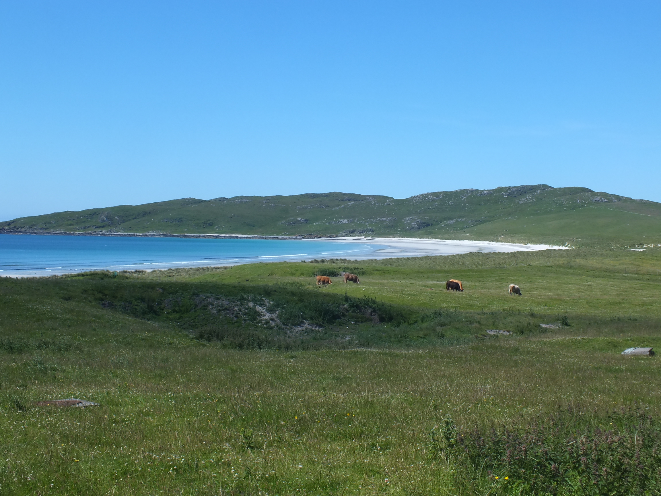
The photo above is of Balephuil Bay and Tràigh Bhì, looking east towards Càrnan Mòr/Ben Hynish (with the golf ball shaped radar station on it’s summit. From the dunes behind Tràigh Bhì I was able to see, and photograph, Skerryvore Lighthouse ten miles to the south and a wee bit west. I did not include that photograph here for two reasons. Firstly, I had to use a 30x zoom factor to achieve a reasonable size in the picture and because of this it did not turn out as sharp as I’d have liked and, secondly while associated with Tiree, the Skerryvore Lighthouse is not actually on Tiree so I decided that including it would have been a bit out of place.
The above photo is also of Balephuil Bay and Tràigh Bhì but this time looking west towards Beinn Ceann à Mhara. I only include both this photo and the previous one to show both Beinn Ceann à Mhara and Càrnan Mòr/Ben Hynish. The area to the north of Tràigh Bhì is a large area of dunes which hosts an easily accessed parking area (not paved) which gives easy access to all the surrounding beaches and both hills.
Note that in getting to the area of the above three photos I actually used the road network to get there. This took me east across to the road that runs down to Hynish and then back west on the road to West Hynish before taking the very minor road to the parking area in the machair mentioned above. I decided, however, to present the photographs as if I stuck to the coast all the way from Tràigh Thodhrasdail to Hynish. This to provide a seeming continuity with the photos.

The photo above is of Hynish pier. Hynish was, at one time, the base for the support of Skerryvore Lighthouse before, for some reason, the base for this was moved to Erraid. Apparently the blocks to build the lighthouse were cut at Hynish and the off duty keepers also lived there. Hynish includes a museum and visitor centre.

The above photo is of a white house at Mannal (which is just north of Hynish). This cottage, as can be seen, has been fitted with a felt roof (don’t ask my why this material is called 'felt' - it just is) instead of the normal thatch. It’s only on Tiree that I’ve seen this innovation. Once installed I suspect the felt roof is easier to maintain and repair and, therefore, cheaper. In addition to that, I suspect that thatchers, with every passing year, are becoming rarer and rarer.

The photo above is of the Balinoe standing stone. Balinoe is a wee bit north then west along a very minor road. It is in a field to the right of an even more minor road leading to the Tiree Camping Ground.

The photo above is of Sorobay beach and bay (Sorobaidh or Shorobaidh in Gaelic).
.JPG)
The above photo is of Tràigh Bhàgh at Crossapol.


The above two photos are both of the Old Harbour at Scarinish.

The photo above is of one of the upgraded ‘white’ houses at Scarinish.
Note: That completes the anti-clockwise picture tour of the “fat” part of Tiree. The tour continues along the B8069 to Caolas at the north eastern point facing across the Gunna Sound towards Coll - plus a couple of side trips to places along the way.

The above photo is of a part of Vaul. I say “part” because it looks like Vaul is an area, rather than a township or village, which stretches all the way from the main road at Gott Bay to the north western coast - with many houses and crofts houses strung out along the way.

The photo above is of the broch known as Dun Mhòr Vaul. By the time I got here there were signs that the weather was getting worse quickly - so I did not go over to investigate the ruins more closely, which is why I only managed to get a picture from some distance away. Note that just a bit to the north east of the broch is Dun Beag which, given it’s shape, is thought to be a far more recent fort rather than a really ancient broch.
.JPG)
The photo above is another picture of Tràigh Mhòr and Gott Bay - only this time towards the south west and Scarinish (as opposed from Scarinish towards the north east).

The above photo is of Salum beach and bay - which is just a bit north and east of the northern extent of Vaul.

The photo above is of Milton harbour. Milton is very close to the end of the road at Caolas down at the north eastern corner. There is another broch near by but I did not take the time to explore it.

The above photo is the end of the road at Caolas looking across Gunna Sound towards Coll. This is not a particularly exciting picture - but it ends my tour where the road ends.

.jpg)
Comments
Post a Comment