Inhabited, west coast Scottish islands - Eigg
The Isle of Eigg is the second largest, after Rùm, of the Small Isles. It is also the most easterly and only about ten miles west of the Scottish mainland. It is roughly triangular in shape with a bite out of the coast (the Bay of Laig) which faces north westwards towards Rùm. There seems to be some dispute if the name has Gaelic or Norse roots although it probably means ‘notched’. Does that definition refer to the ‘notch’ created by the Bay of Laig or the ‘notch’ in the skyline created by An Sgurr (see below) - or is the name derived from something completely different? It would seem that there is no definitive answer to that so it looks like everyone can decide for themselves. That aside, Eigg is roughly 5 miles long, north to south, and 3 miles wide, east to west. Running down the centre of the northern end of the island is Beinne Bhuide, which appears to be reasonably flat on top but surrounded on three sides (not the south) by almost vertical cliffs with grassy slopes below them running down to the sea. I’m not sure but Beinne Bhuide seems to be the name of the entire ridge, not just any particular high point. The slopes on the western side (of the ridge) are wider and nothing like as steep as on the eastern side and therefore provide good space for habitation and crofting. Several of Eigg’s townships are located along this strip of land. The eastern grassy slopes are far steeper and, as far as I can tell, are devoid of any habitation.
The southern end of the island is pretty rough and tumbled with several small summits around the 390 metre mark. The most famous, highest and distinctive of those is An Sgùrr (393 metres). The sight of the Sgùrr of Eigg breaking the skyline is almost Eigg’s trademark. In appearance it is similar to Beinne Bhuide, at the north of the island, in that the reasonably flat summit is surrounded on three sides (but not, this time, on the west) by vertical cliffs. In this case, however, the land below the cliffs is not steep grassy slopes sweeping to the sea but steep grassy slopes tumbling down to the surrounding, rough, landscape mentioned above. I’m not sure if both sets of cliffs are of the same rock (pitchstone for An Sgùrr) or produced at the same geological period, but there is a similarity in appearance. Note that I did find one Internet article about this but it was so technical it might as well have been written in a foreign language. Having said that that, I got the impression, from this technical article, that rocks in both areas are not the same - but you can do your own research on this. Note that this southern section is almost totally uninhabited apart from Kildonan and Glamisdale, both on the east coast, which is where the jetty is located.
Eigg is community owned (the Eigg Heritage Trust), having been bought from an absentee landlord in 1997. Because of this the community owns most of the businesses, including a company which generates just about all of the island’s electricity. Eigg’s population would appear to be around 100 (a couple of articles claimed a few over 100 while a couple of others claim just under 100). This is mainly split between a few townships on the west coast around the Bay of Laig and Kildonan and Glamisdale on the southern end of the east coast. The latter, as previously mentioned, is where the ferries from Arasaig (summer only) and Mallaig arrive. This is also where most of Eigg’s facilities are to be found (the exception being a restaurant at Lageorna, near the northern end of the road at Cleadale). The facilities at Glamisdale includes the community owned island shop, gift shop and a cafe bar (which I’m advised by a friend, who visited during 2023, sells a very fine Eigg brewed IPA). The main incomes for the population are derived from crofting and tourism, probably some fishing and working for the island owned electricity company. It would also appear that a fair percentage of Eigg’s population have moved there in recent decades but the vast majority of them are permanent residents on the island and are not ‘summer only’ visitors.
There’s is a low lying valley (or bealach in the Gaelic) between Beinne Bhuide to the north and An Sgùrr at the south and it is this dip in the land that the road takes advantage of to get over to the west coast from the jetty at Glamisdale. It is perhaps worth noting that, like Muck (and the other Small Isles), visitors are unable to bring over their vehicles and that getting about on the island is by foot, bike or taxi. I couldn’t find a great deal of information regarding the natural world and what flora and fauna might be found but there is the usual sea life for the area to be found around it’s shores including minke whales, seals and dolphins. There would appear to be a wide selection of birds to be seen, including eagles (probably both golden and sea), buzzards, kestrels and owls as well as cuckoos and many others. Wildflowers seemingly abound - although I could see no mention of anything rare. The only animal life mentioned in the articles I read were sheep, cattle and otters. As far as I can tell, Eigg is not home to any red deer. Eigg also boasts a couple of wooded areas. One of those is just west of the jetty and below the Sgùrr while the other, and larger, lies to the south of the road between Glamisdale and Laig in the middle of the already mentioned bealach.
My visit to Eigg was for only a few hours while the ferry unloaded, went on to Muck and came back again (similar to all my Small Isles visits) but what is there to do on the island if staying overnight or for a longer break? There are several sandy beaches - a couple near the ferry jetty around Glamisdale and Kildonan and also over on the west coast between Laig and Cleadale. The beach at Cleadale, Tràigh na Bigil, is also called the ‘singing sands’ because at certain times the beach will make a ringing sound if you stamp on it. My OS phone map seems to indicate that Eigg is surrounded by beaches but I don’t think that is the case (maybe at very low tide) as photographs indicate a mainly rocky coastline (which might also be fun to explore).
There are plenty of walks which can be undertaken. These would include An Sgùrr (a long tramp from the west) as well as Beinne Bhuide running up the central spine of the island. The maps, in fact, indicate a couple of paths zig-zaging up to the top of Beinne Bhuide from the west coast but it looks to me as if they would be rather steep and dangerous so it might be best going up Beinne Bhuide from the south (via the bealach already mentioned). There are also a couple of nature reserves which offer guided tours. Walking also affords the opportunity to spot the flora and fauna mentioned above. There are also a couple of standing stones to go looking for along with a couple of more recent historical sites, like the ‘massacre cave’, to visit. On first look there does not appear to be much in the way of historical sites to explore but a read of the famous, online encyclopedia (and other sites about Eigg) suggest there are actually quite a few such sites to go looking for. It should be mentioned, at this point, that there are quite a few Internet articles on Eigg which provide more detailed and comprehensive information on the island than this post does.
It also seems that bikes and kayaks can be hired - and of course just relaxing is always an option, especially if you get some good weather.
I’d be more than happy to revisit Eigg and spend at least two or three days exploring it further (a few hours close to the jetty was simply insufficient - but at least I was able to tick if off my bucket list).
As always, a few photographs from my trip are included next.

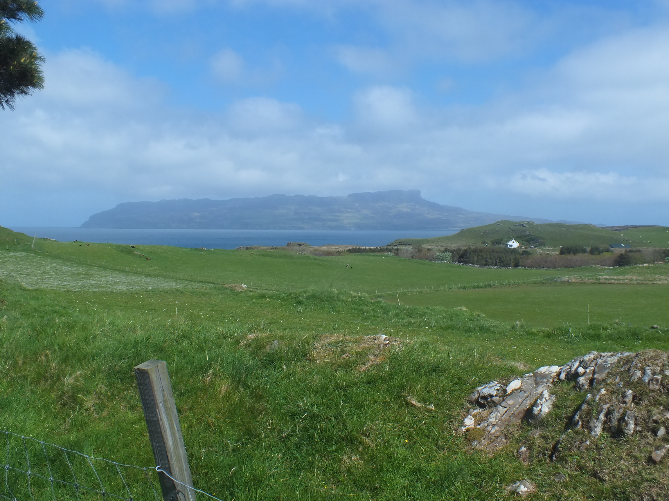
The photo above was taken from the CalMac ferry to Rùm, looking south east towards the west coast of Eigg. The western slopes of Beinne Bhuide are nearest the camera while An Sgùrr can be seen in the distance. Note that I normally leave my photographs at the default size to, I assume, save space. In this case I exlarged the photo as Eigg was very small and distant in the original.

The photo above was taken at roughly the same time as the first photo - only zoomed in a bit on the cliffs near the north west of Eigg so that a comparison can be made between them and the ones on the other side of the ridge and the ones on An Sgùrr.

The photo above is of the cliffs at the north eastern corner of Eigg.

The above shot was taken approaching Glamisdale, looking over the bealach between the north and south of Eigg with Rùm’s hills/mountains beyond.

The above photo is of the jetty at Glamisdale from the CalMac ferry just before docking.

The photo above is of a sandy bay at Glamisdale jetty with eastern buttress of An Sgùrr looming above.

The above photo is of the Shop, Cafè and gift shop at the Glamisdale jetty.

The photo above is of a standing stone close to the Glamisdale jetty. It was found lying flat (I don’t know where) but put back up to mark the successful community buy out of 1997. I presume (I didn’t look) that the podium in front of it explains the circumstances that led to this.

The photo above marks the furthest extend of my walk on Eigg. It shows the house closest to An Sgùrr (almost in it’s shadow). I also included it just to display the Sgurr’s cliffs more clearly.
The photo above was actually taken on Muck. It looks across to the the southern coast of Eigg and gives another perspective on An Sgùrr.

.jpg)
Comments
Post a Comment